In a major-power conflict, we must be ready to cut China off from critical resources, markets, infrastructure, and shipping lanes. We must be prepared to do this all over the globe, not just in the Indo-Pacific. We must also clearly denote the bounds of American influence over the Western Hemisphere and remove any ambiguity. This requires control of chokepoints, coastal corridors, and strategic islands.
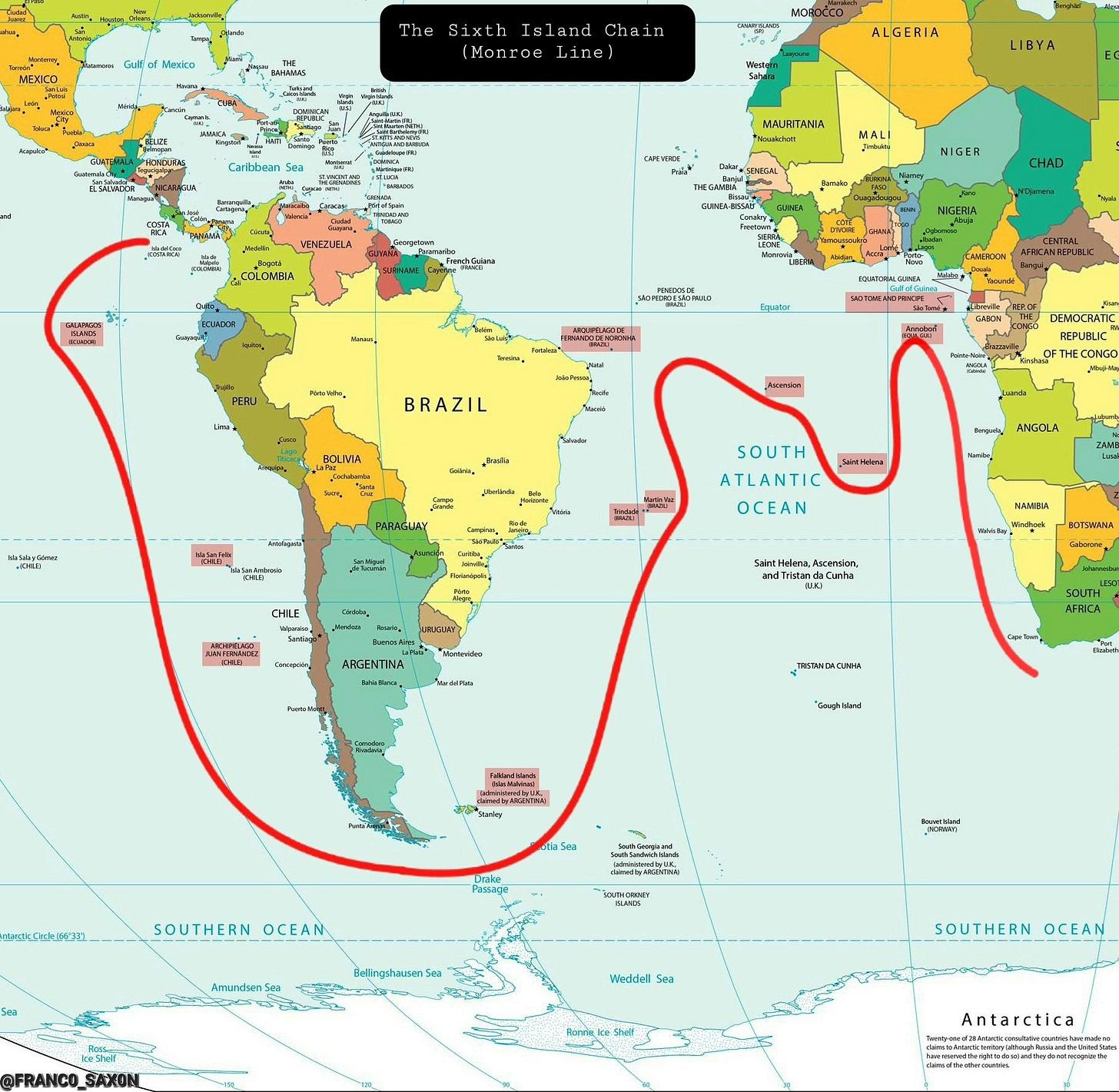
This doctrine builds on the principles of sea power and containment laid out by A.T. Mahan and Nicholas Spykman, and it reflects the scale of China’s global presence. It calls for the creation of a Sixth Island Chain. I call it the Monroe Line. It is a strategic perimeter built to contain China, sever its access to Africa and South America, and lock down the Western Hemisphere as a fortress. Much of my proposed Sixth Island Chain is already in place. It only needs a bit more development to form a highly coherent hemispheric defense and containment architecture. With only a few executive actions and agreements, the President can execute it using SOFAs and existing Title 10 authorities to secure access, rotations, and joint operations on partner soil. No new legislation or congressional vote is required.
Why Island Chains Matter
China’s encroachment and deepening presence across Africa and South America are not things we can ignore. They are strategic threats.
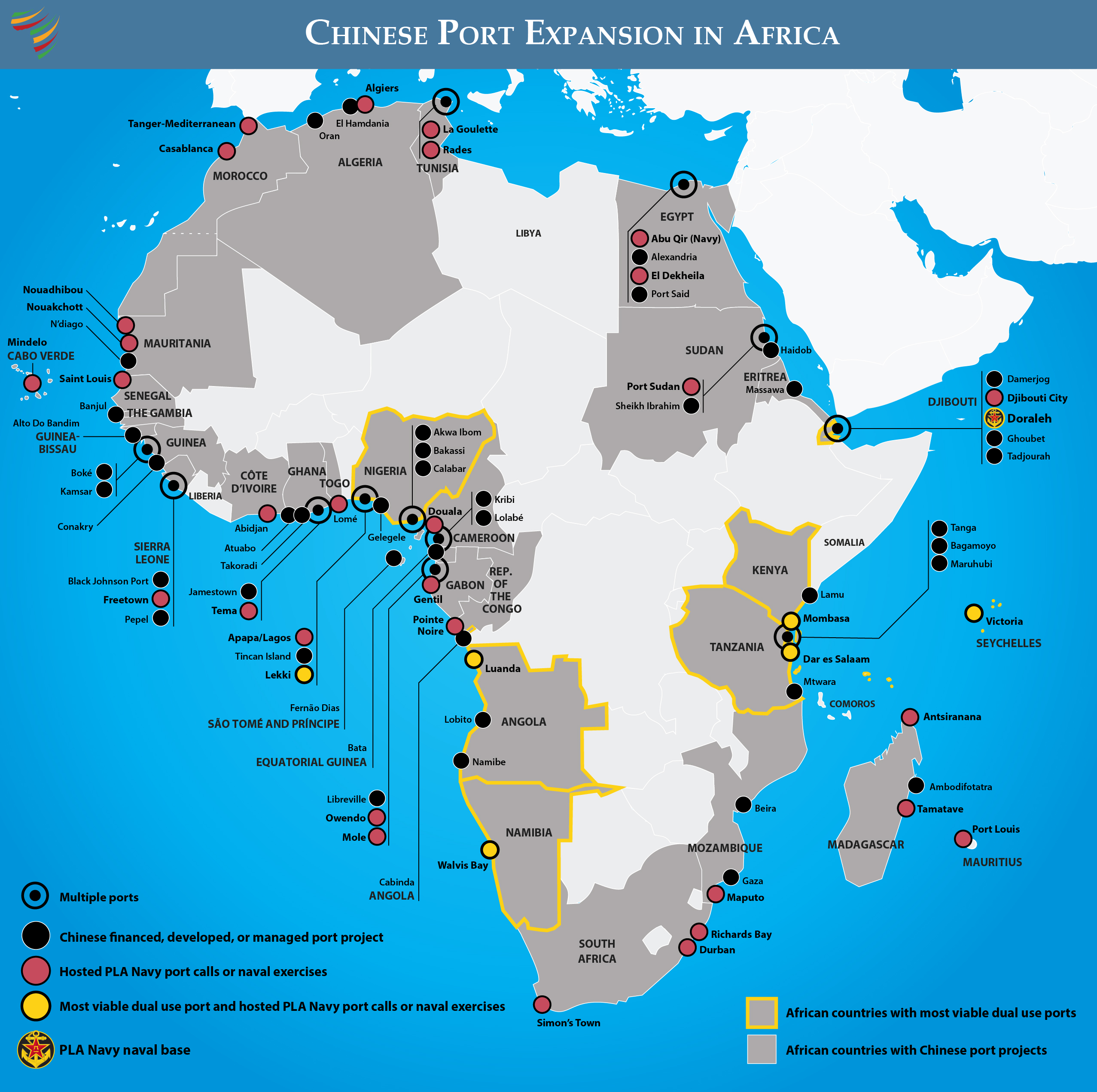
Beijing is building a latticework of dual-use infrastructure, including ports, airfields, railways, and roads, all capable of pivoting from commerce to military use overnight. The US response has not been nearly energetic enough and lacks urgency. There has been a lot of attention on the Indo-Pacific and the forward deployed island chains there, as there should be, but we need to secure our backyard as well. For decades, US naval doctrine has relied on a series of geographic barriers known as island chains to contain China and maintain a strong geostrategic posture. These chains are defensive and offensive lines to keep China bottled up and the US insulated. They are geographically advantageous barriers that are militarily built up to limit an enemy’s freedom of movement and restrict access to resources.
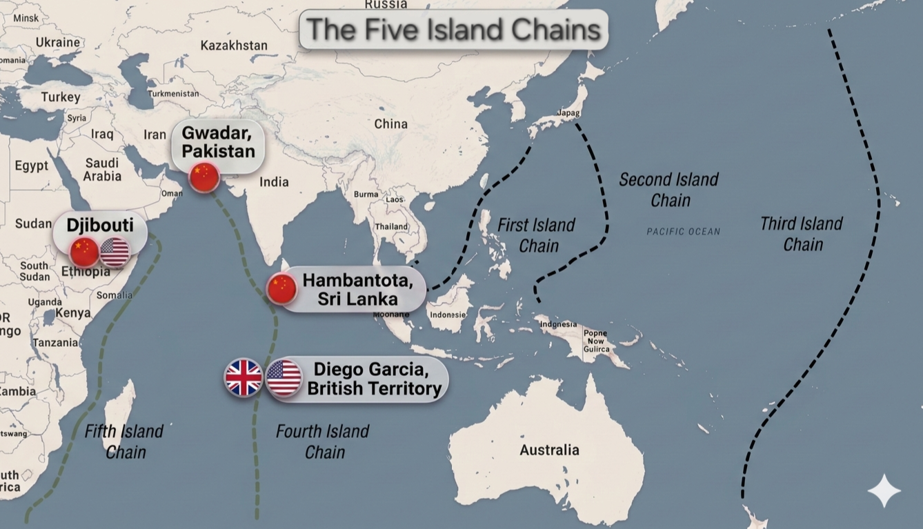
The First Island Chain is the closest maritime barrier around China. It runs from the Kuril Islands through Japan, Taiwan, the Philippines, and down to Borneo. This chain has one primary purpose: to keep China bottled up and contained within the shallow seas close to its coast. Chinese naval forces operating inside this chain are under constant surveillance and at risk of being cut off if conflict erupts. The purpose of the First Island Chain is to prevent China from freely projecting power into the wider Indo-Pacific. Inside this chain, the Chinese Navy is forced to operate under the threat of missile strikes and naval blockades. It also allows the US complete control over the Strait of Malacca, through which China imports about 80% of its oil.
If the First Island Chain were to break under Chinese pressure, Chinese vessels, manned and unmanned, could have a fairly clear line to the Atlantic. They could reach the Indian Ocean through the Malacca and Sunda Straits and use their control of Hambantota in Sri Lanka to lock down the ocean and project power. From there, they’d be positioned to maneuver toward East Africa and eventually the South Atlantic.
The Second Island Chain sits farther out, beginning at the Izu and Bonin Islands near Japan, through the Marianas and Guam, and toward Palau. It provides a deeper defensive and offensive perimeter for US forces, which gives more reaction time and a broader area from which to conduct strikes or enforce blockades.
The Third Island Chain extends across the central Pacific, from Alaska’s Aleutians through Hawaii and American Samoa to Oceania. It is a staging ground for projecting power into the Western Pacific while also protecting the US mainland. In a war with China, much of the staging to support the frontline would take place in the Second and Third Chain.
More recently, strategists have identified and proposed a Fourth and Fifth Island Chain in the Indian Ocean. The Fourth Island Chain begins at Gwadar, through Sri Lanka and the Maldives, and reaches Diego Garcia. This chain is meant to block China’s naval expansion into the Indian Ocean, the Middle East, and Africa. China already has a 40-year lease on Gwadar, Pakistan and a 99-year lease on Hambantota Port, Sri Lanka. The recent dispute over who will possess Diego Garcia is about this strategic struggle. Losing it would give China a critical foothold in the Indian Ocean and allow them easy access to East African markets and oil out of Hormuz. Furthermore, if China ever acquires Diego Garcia, they will consolidate the Fourth Island Chain, cut the Indian Ocean in half, and have much easier access to the Atlantic.
The Fifth Island Chain also sits in the Indian Ocean, beginning at Camp Lemonnier in Djibouti, down the East African coast, through the Mozambique Channel and around South Africa. Its purpose is to enclose China’s base in Djibouti and keep China from freely operating across Indian Ocean sea lanes.
The Monroe Line
Despite all these barriers, none of the existing island chains addresses China’s growing reach into the Atlantic or its push into South America and West Africa. In the event of war, these are parts of the globe that we will have to defend. That is the strategic gap the Monroe Line is designed to fill.
The purpose of the Monroe Line is to control sea lanes, cut China off from markets and resources in emergencies, and preserve US naval dominance of the Atlantic ocean. We must be ready to lock the hemisphere down and strangle China’s economic lifelines if conflict comes. In peacetime, the Sixth Island Chain secures trade, enforces maritime norms, gathers intelligence, deters coercion, binds partners through routine presence, and makes American hemispheric power the default condition, ultimately changing the strategic calculus. This ensures crises are managed early and influence never has to be rebuilt under fire. Instead of deploying and moving forces to respond to a crisis, it’s better to have them already in place, securing key positions on the chessboard, locking down important files, ranks, or diagonals.
The Monroe Line would become the Sixth Island Chain and would stretch across the mid-Atlantic, splitting the Atlantic in half, locking down West Africa, wrapping around the southern tip of South America, and closing back up through the Pacific to the Galapagos.
Like the other island chains, this would operate like General Winfield Scott’s Anaconda Plan during the Civil War. This chain would be ready to cut off Chinese access to vital regions at a moment’s notice. It would be a forward-deployed perimeter to deny Beijing access to the Atlantic and protect US interests in the Western Hemisphere.
The goal is clear. The US has to sever China’s sea lines of communication (SLOCs) and deny it access to South American and West African markets, resources, and infrastructure. Chinese companies and state-backed actors have been setting up dual-use infrastructure like ports, railways, and airfields across both continents. These projects appear commercial but could quickly be turned to military use. The Monroe Line would let the US shut down these assets and stop China from using South America and West Africa as sanctuaries and resource colonies, especially in a war. In peacetime, these nodes change Beijing’s calculus, leading it to limit its investment exposure in the region not only because it cannot guarantee its supply lines to South America in wartime, but also because of increased and persistent American pressure. It would have a discouraging effect on Beijing’s investment in the Western Hemisphere.
Blocking Chinese access to these two continents is essential for protecting our hemisphere and keeping vital resources like lithium, copper, and oil out of Beijing’s reach. Since South America exports such a large amount of food to China, we must be prepared to cut that off, too. Roughly a third of China’s food imports come from South America. China cannot produce enough food domestically to sustain its population. The Lithium Triangle, which is Argentina, Bolivia, and Chile, contains more than half the world’s known lithium reserves. Chinese companies have significant access to South American lithium and have invested a great deal there. The Monroe Line would put the US in a strong position to monitor, restrict, or immediately sever these flows if war breaks out.
Beyond restricting resource exports to China, the Monroe Line would bring other critical benefits. It would secure the major shipping routes that run vertically along the length of the Western Hemisphere and flow into Europe across the Atlantic.
Protecting these sea lanes ensures the Western Hemisphere remains a fortress and insulated from Chinese naval reach and influence. Keeping these lanes secure is absolutely essential for transatlantic trade and the economic stability of both North and South America, as well as Europe, especially during war. The goal would be to achieve a high degree of hemispheric autarky and then adopt a geostrategic posture that can defend the associated trade routes. This is that geostrategic posture.
The Monroe Line would assist US intelligence with surveillance. Bases and installations along this chain could host radar, sonar arrays, and signals intelligence facilities that track maritime and aerial activity across the Atlantic and South Pacific. Some bases could even host submarine pens. From there, the US could monitor Chinese shipping, fishing fleets, submarines, and naval movements. In both peace and war, this would be a valuable strategic position. Many of the world’s major fiber optic cables run across the Atlantic, carrying huge amounts of data every day. Roughly 95% of intercontinental internet traffic travels through undersea cables that run along the seabed. The Monroe Line would give the US forward positions to monitor these cables and protect them against sabotage and espionage, which would ensure continuity of communication during a conflict. We also need to be ready to protect other critical seabed infrastructure, like power transmission lines, oil and gas pipelines, and military sensor networks from sabotage and espionage. In a world of increasingly more numerous and sophisticated unmanned underwater vehicles (UUVs), securing this subsea infrastructure is essential.
These bases would also be refueling hubs and logistical, which would extend the operational reach of the US Navy, Air Force, and Marine Corps. It would let the US move quickly between regions without having to rely on continental bases or allies. Perhaps most importantly, the Monroe Line would act as a strategic insurance policy. Even if it is never used in a hot conflict, the fact it even exists changes the strategic calculus in Beijing. It would deter aggression and prevent China from assuming it can operate freely in the Atlantic or count on South America and West Africa for sanctuary and resources. It would raise the cost of any potential conflict and discourage investment from Beijing.
Establishing the Monroe Line, combined with US control over the Bering Strait and the potential acquisition of Greenland, would lock China out of the North Atlantic entirely. Even without annexing Greenland, as long as Greenland stays friendly, the Northwest Passage and Transpolar Sea Route are ours to control in war. Russia’s Northern Sea Route wouldn’t have access to the North Atlantic due to Norway’s proximity to the route and US control over the Bering Strait and GIUK gap. This would cut China off from sea lanes both from the south and from any polar approaches. The North Atlantic would become a completely closed domain for China.
Building the Monroe Line: Key Nodes
Below are the core nodes of the Monroe Line, organized from east to west. We review each node in detail below.
- Sao Tome and Principe
- Annobon Island, Equatorial Guinea
- Ascension Island and St. Helena
- Fernando de Noronha or alternative Brazilian offshore facilities
- Falkland Islands
- San Felix Island, Chile
- Galapagos Islands, Ecuador (Baltra or rotational alternatives)
West Africa
Starting in the Atlantic, the first node of the Monroe Line would be in West Africa, starting with Annobon Island. The US should seek a lease from Equatorial Guinea to establish a permanent presence there. We have a good relationship with them. There isn’t a country that invests more in Equatorial Guinea than the US.
Nearby, Sao Tome and Principe are also critical, since China is attempting to secure a deepwater port there. The US needs to act quickly to secure a lease with Sao Tome and Principe before China can. These islands would give the US control over West African shipping lanes and the ability to project power into Africa’s interior. Especially important are the cobalt routes coming out of the Democratic Republic of the Congo, resources currently dominated by China. As mentioned earlier, the DRC has about 75% of the world’s cobalt, and almost all of it goes to China. All of the ports that China has developed in West Africa would be inside the Sixth Island Chain and rendered immediately useless for them in the event of war. They would all be contained by a permanent network of militarily built up nodes.
Sao Tome and Principe offers the most permissive environment. A long-term lease for air and port facilities is legally viable and politically defensible. Like with Equatorial Guinea, the US has a good relationship with Sao Tome and Principe. A lease or exclusive use agreement paired with US infrastructure investment would give the US control over the African interior and maritime routes. Annobon Island in Equatorial Guinea would support a similar model.
Mid-Atlantic
The next link in the chain would be Ascension Island and Saint Helena, both of which are British territories with existing strategic infrastructure such as ports and large airfields. On the island of Ascension is a massive Royal Air Force base, which is jointly operated by the RAF and US Space Force. Saint Helena has an international airport. Due to its central location between South America and Africa, Ascension acts as an important guardian of the southern approach to the North Atlantic.
Further west lies the Brazilian island of Fernando de Noronha. It already has a good airfield, originally built by the United States Army Air Forces Air Transport Command in 1942. During World War II, it was a link between Brazil and French West Africa. The route moved cargo, aircraft, and personnel for the Allied campaign. Its strategic value is still significant today. The US should either get a lease on Fernando de Noronha outright, lease the airfield and some land for a port facility, or secure joint operational rights with Brazil. Beyond the airfield, the US should invest in expanding and modernizing the facilities and build a port for naval and logistics operations. Like Sao Tome and Principe, Annobon, and Ascension, this island would be a forward hub for monitoring or interdicting maritime traffic and rapid response across the mid-Atlantic corridor. It would also allow the US to block access to South America and the North Atlantic.
If securing Fernando de Noronha from Brazil proves too difficult, the US should negotiate for a nearby Brazilian shoal and construct new facilities there, using artificial island-building methods like those employed by China in the South China Sea.
To establish a foreign base, Brazil’s constitution requires approval from their congress, which would be difficult, so US presence must rely on cleverly structured access and co-location agreements at Brazilian owned facilities. This preserves Brazilian autonomy while enabling US presence and operation. As mentioned before, if political resistance remains, offshore shoals and artificial island construction remain a viable alternative that would be worth exploring.
Southern Atlantic and Pacific
Moving south, the Monroe Line would pass through the Falkland Islands, where the US should pursue a joint base with the British or even pursue a separate one if possible. The islands sit near the Drake Passage, which would help control and monitor southern maritime traffic that is transiting between the Atlantic and Pacific. By expanding and jointly operating a Falklands base with the British, the US can secure the South American chokepoints of the Drake Passage and the Strait of Magellan. Having an American footprint down there in the Falklands is also important for checking any Antarctic ambitions China might have. The US must keep an eye on the expanding Chinese activity in Antarctica.
The United Kingdom is not really an obstacle here. Joint basing, infrastructure expansion, and rotational US presence can be framed as alliance burden sharing and South Atlantic stability. The Argentine question is manageable, especially with Javier Milei as president and with the recent bailout and economic ties. Argentina can be folded into logistics, fuel supply, Antarctic support operations, and a South Atlantic maritime security forum headquartered in Buenos Aires. Quiet US support on IMF flexibility and trade access gives benefits and assists in shelving sovereignty issues. The expansion needs to be clearly framed around countering Chinese fishing fleets and Antarctic ambitions, not Argentina.
San Felix Island
Then comes San Felix Island off Chile’s coast. Currently underdeveloped, San Felix offers tremendous strategic advantages and possibilities. The US should partner with Chile to upgrade the airfield and build a deepwater port. Ideally, the US would secure ownership and operational control through a partnership or something like an outright 99-year lease, but a joint operation agreement would be the easiest option. It is centrally located and able to project power either north toward the Panama Canal or south toward the tip of South America, which, like the Panama Canal, is a maritime chokepoint and the Pacific’s gateway to the Atlantic. This is the same strategic value Malta held for the British, allowing rapid deployments to Gibraltar and the Suez Canal. It also resembles the role Diego Garcia plays as a central hub for US operations into Asia and the Middle East. San Felix’s topography adds some more value due to a western hill at 200 meters that provides an ideal site for radar installations, ISR, and comms. San Felix has the potential to be the guardian of Pacific South America.
Chile will require a sovereignty conscious approach, but its political environment makes deeper cooperation more attainable over time, including the possibility of a long-term lease. San Felix Island can be jointly developed under Chilean command with joint US-Chilean operational control. With the election of Jose Antonio Kast of Chile, who is aligned with the US and President Trump, this will open new opportunities in Chile and make geopolitical moves like this more viable than ever. A mutually beneficial framing could be the development of an early warning system to cover the hemisphere’s southern approach over Antarctica. Between San Felix, the Falklands, and maybe even one in the mountains on the Chilean mainland, that would make for a solid southern early warning system.
Closing the Chain
The Monroe Line would close at the Galapagos, specifically Baltra Island. Originally built by the US during WWII to defend the Panama Canal, Baltra is still strategically significant. On top of protecting the Panama Canal and closing in Central and South America, the end node at Baltra Island in the Galapagos would also help prevent any renewed ambitions by China to build a Nicaraguan Canal as an alternative to the Panama Canal, or any other transoceanic projects. A long-term lease with Ecuador would restore US presence in an area which is increasingly influenced by China’s economic and infrastructure investments. While the US is looking at leasing the airbase and port at Manta on Ecuador’s mainland, I believe we should lease Baltra again. Manta should be secured, but Baltra Island should also. We should restore and expand the old World War II airfield on Baltra, which would give the US two airfields there. At some point, a deepwater port with naval piers should be built on the north side of the island.
Ecuador will also require a sovereignty conscious model at the outset, though as the relationship matures, a long-term base lease could possibly be acquired. For Ecuador, pursue rotational access and joint-operations tied to canal defense, counter narcotics, and maritime enforcement around the Galapagos or on the mainland near Manta. If made a priority, Ecuador could be convinced to alter their constitutional ban on foreign bases, as they have done before. Like Kast of Chile, Daniel Noboa is now president of Ecuador and aligned with Washington, which opens up opportunities for deeper cooperation that were not politically viable before.
Implementation Doctrine
The Sixth Island Chain is a framework that aligns US access and control with the political and legal realities of each host nation. The objective is a durable presence that cannot be easily reversed once established, not ownership for its own sake. With that said, there is a reliable blueprint. Access absolutely must be framed as a partnership. The US should start with layered agreements like defense cooperation accords, Status of Forces Agreements (SOFA), and EDCA-style arrangements that allow access and prepositioning without provoking domestic backlash. Once normalized, these can mature into long-term leases and naval stations. Only select countries will consider a near-immediate lease agreement.
To avoid constitutional bans on foreign bases in host countries, the unique arrangement between the US and Honduras for access to Soto Cano Air Base is also a framework worth exploring. Despite having a ban in place, the US has up to 1,500 personnel stationed there and effectively runs the base, not Honduras. This arrangement has existed for over 70 years.
Every deal has to deliver visible value. Infrastructure is the main lever. Back US firms and use Development Finance Corporation financing. Ports, airfields, roads, power, and communications upgrades tied to US access can positively turn military presence into economic development. The US should offer heavily subsidized, highly attractive deals to these countries and rip-and-replace Chinese systems with US tech firms to reassert technological control, protect data sovereignty, roll back Chinese influence across the hemisphere, and buy goodwill through visible crime reduction enabled by modern surveillance. Patrols, intelligence and technology sharing, training, and equipment strengthen local sovereignty and make US presence defensible at home. Trade and finance are the last ones. Preferential market access, investment guarantees, and debt support often outweigh what China offers.
In Closing
Publicly, this architecture is about maritime security, anti-narcotics, sovereignty enforcement, humanitarian aid, infrastructure protection, and disaster response.
Privately, it is containment. Each node stands on its own politically. Together, they form a continuous barrier that secures hemispheric trade, denies adversarial penetration, and locks the Western Hemisphere into a defensible perimeter. The Monroe Line would be the first true Atlantic-Pacific barrier. It would make it clear to Beijing, and to any other potential adversaries, that the Western Hemisphere is not open for exploitation. If the US is going to be prepared for war, keep the Atlantic free, and secure its own hemisphere against Chinese influence, the Monroe Line is required. The island chain strategy works in the Pacific. It is time to bring it to the Atlantic and Southeast Pacific to secure the Western Hemisphere as a fortress against any who would seek to challenge American influence and security.
